Please support the residents of Green Tree Brae, in building a wall to help prevent devastating flood water from damaging their properties, and consequently support the diversion of the right of way which runs across their land.
Why is this important?
The residents of Green Tree Brae need your help to prevent any future flooding to their properties. We have a simple solution to alleviate the threat of flooding to our homes. We are proposing to remove the foot bridge and build a wall to block the gap between our properties and the burn. We will also require to divert the right of way which runs across our land from Dyke side to the Main Street (an addition of 40m).
The flood prevention measures which were put in place in 2008 have failed and are not fit for purpose. We are now living with the constant threat of flooding.
We want to make you aware of the devastating situation we are in and we need to know how residents within the village feel about the difficult decision to request the diversion of the right of way.
It has come down to a choice between keeping a short cut accessible or protecting our homes and families from the threat of flooding. We have been given the advice from Fife Council that we need community support if we want to divert the right of way with a wall to prevent the flood water.
Unfortunately some of our friends and neighbours who have also been affected by the flooding do not have such an easy solution. We are hopeful that local residents will help us by supporting the only option that makes sense.
Can you please pledge your support by signing our petition?
To read the full story of the flooding situation at Green Tree Brae, please continue reading below.
Thank you for your support - the residents of Green Tree Brae.
**************************
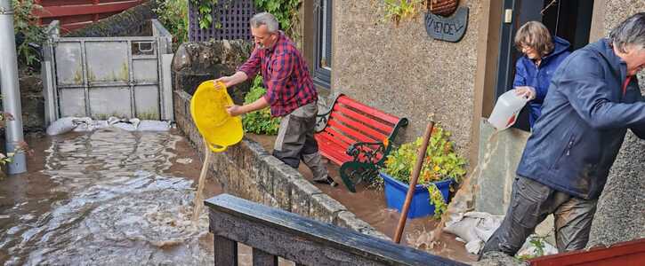
Green Tree Brae has been hit by flooding a number of times, causing financial, emotional and physical distress. The homeowners were forced out of their homes for 6 months due to significant flood damage in 2008. Flooding occurred again in Aug 2020, when the Fire Brigade told the homeowners to evacuate due to safety concerns. The flooding in 2020 was extremely dangerous, flood waters carry a risk to life from the speed and depth of water as well as from the contamination carried by it.
It is devastating that our 5 young children have been traumatised by the threat of the flooding and that two OAP's had to wade through two feet of flood water carrying wet and heavy sandbags in an effort to protect their homes, when there is an easy and quick way to ensure flooding does not happen again.
Freuchie Burn flows within a 1 meter of the nearest dwelling, flowing directly from moorland near the summit of East Lomond Hill. The flow is straight downhill with only one bend where the burn flows under the A912. The last Kilometre before reaching Freuchie is across farmland where new field drains, new extra- large culverts and extensive water channel ground works have replaced the old drainage resulting in a much greater volume of flood water travelling at an increased velocity into the village.
The footbridge is built at the narrowest point in the burn, where water is forced between two banks going from 8m wide to a little over 1m at the bridge. Water flowing through this choke point is forced upwards to a height of approximately 3m and the speed of the water is accelerated substantially at this point.
The flood water passes over and under the footbridge which then becomes an obstruction attracting all sorts of debris which is driven at speed by the flood. A barrier attached to the footbridge which was installed after the flood of 2008 failed to retain the water as the speed, depth and volume of water were simply too much for it. The barrier has at times required to be physically closed by the residents on occasions when it failed to close properly. There has been no engineering maintenance carried out on the bridge/ barrier in over 12 years. This barrier is not accredited by any standards organisation as being fit to function as a flood barrier.
All of the natural flood planes have been eradicated by the construction of new housing and field drainage. The remaining burns walls which contain these vast volumes of water within the watercourse are under considerable strain and should a garden wall collapse under this weight of water it would most likely destroy the two properties nearest the burn, which is why the residents were instructed by the emergency services to evacuate their property.
At the same time as Freuchie Burn was breeching the barrier on the footbridge, secondary flooding was taking place. This happened when floodwater ran down the brae and across the gardens. Rainwater under normal circumstances would drain through the rainwater drains located front and rear of the properties, however as previously mentioned these were blocked with sandbags and impossible to use because of the high water level and the velocity of the water in the burn. By using boards, buckets and brushes over a protracted period of time the water was eventually driven from the property’s front doors by the homeowners.
To be flooded once is unfortunate, to be flooded twice is negligent, to be flooded three times is a disgrace. We, as the homeowners are just asking for support to protect our homes, at no cost to the village, Council or community.