
5,000 signatures reached
To: Spelthorne Borough Council
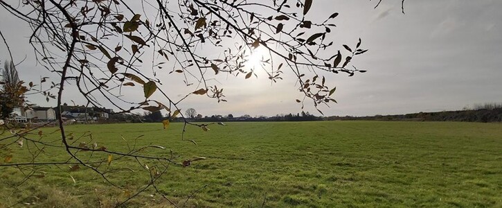
Save our Green Belt in Spelthorne
We are asking Spelthorne Borough Council not to release 15 Green Belt areas (24.8 hectares) currently identified in the Draft Local Plan for building purposes and to protect the entire existing Green Belt in Spelthorne for generations to come.
Why is this important?
Green Belt land fulfils important functions. Its fundamental aim is to prevent urban sprawl by keeping land permanently open - and Spelthorne’s Green Belt boundaries have remained largely unchanged since WW2.
Nonetheless, as part of its proposed Draft Local Plan, Spelthorne Borough Council is
putting forward 15 Green Belt sites across the whole of Spelthorne for building/housing and commercial purposes (see list below). This would mean a loss of 24.8 ha of Green Belt (which is equivalent to over 46 football fields) with a risk of further erosion of our Green Belt in the future. It will result in smaller remaining Green Belt sites which will be weakened as a result and – in turn – become vulnerable to development.
Even though, by law, Green Belt boundaries should only be altered where “exceptional
circumstances” are fully evidenced and justified and where strictly necessary, the Council still decided to release Green Belt sites which are strongly preferred by developers and Green Belt owners as these greatly maximise profit margins. Once stripped off Green Belt status, the value of land can raise 2500 fold (250,000%) and more.
The release of the Green Belt will lead to significant changes to the character of the areas
where they are located and will have a significant impact on local residents as these plots of land have a biodiversity value, a visual benefit, carbon capture value and mitigate flood risks and high temperatures during heat waves – which is now more important than ever during a time of Climate Emergency when more (not fewer) green spaces and rewooded areas are required to counteract carbon emissions.
The 15 Green Belt sites at risk are:
1. AS1/011 Land at former Bulldog Nurseries, London Road, Ashford (0.3 ha)
2. AS2/006 Land East of Desford Way, Ashford (3.33 ha)
3. AT1/002 Land east of Ashford Sports Club, Woodthorpe Road, Ashford (1.15 ha)
4. AT1/012 Ashford Community Centre, Woodthorpe Road, Ashford (0.47 ha)
5. HS1/002 Land at Croysdale Avenue/ Hazelwood Drive, Sunbury (1.68 ha)
6. HS1/009 Bugle Nurseries, 171 Upper Halliford Road, Shepperton (2.28 ha)
7. HS1/012 Land East of Upper Halliford Road, Nursery Road, Sunbury (1.61 ha)
8. HS1/012b Land East of Upper Halliford Road (site B) (2.34 ha)
9. HS2/004 Land South of Nursery Road, Sunbury (0.66 ha)
10. LS1/024 Land at Staines Road West and Cedar Way, Sunbury (1.63 ha)
11. RL1/011 Land at Staines & Laleham Sports Club, Worple Road, Staines (1.59 ha)
12. SN1/005 Land at Northumberland Close, Stanwell (1.75 ha)
13. SN1/006 Land to west of Long Lane and south of Blackburn Trading Estate,
Stanwell (4.83 ha)
14. ST1/043 Land East of 355 London Road, Staines (0.27 ha)
15. ST4/025 Land at Coppermill Road, Coppermill Road, Wraysbury (0.92 ha)
For more information, see:
https://www.spelthorne.gov.uk/article/17619/Emerging-Local-Plan-2022-2037
To get involved or for further information, contact [email protected].